Life As a Surveyor
Surveyor Example Make exact measurements and determine property boundaries. Provide data relevant to the shape, contour, gravitation, location, elevation, or dimension of land or land features on or near the earth’s surface for engineering, mapmaking, mining, land evaluation, construction, and other purposes.
Life As a Surveyor: What Do They Do?
- Plan and conduct ground surveys designed to establish baselines, elevations, and other geodetic measurements.
- Adjust surveying instruments to maintain their accuracy.
- Testify as an expert witness in court cases on land survey issues, such as property boundaries.
- Develop criteria for survey methods and procedures.
- Calculate heights, depths, relative positions, property lines, and other characteristics of terrain.
- Determine longitudes and latitudes of important features and boundaries in survey areas, using theodolites, transits, levels, and satellite-based global positioning systems (GPS).
Featured schools near , edit
What Every Surveyor Should Know
When polled, Surveyors say the following skills are most frequently used in their jobs:
Mathematics: Using mathematics to solve problems.
Speaking: Talking to others to convey information effectively.
Critical Thinking: Using logic and reasoning to identify the strengths and weaknesses of alternative solutions, conclusions or approaches to problems.
Reading Comprehension: Understanding written sentences and paragraphs in work related documents.
Active Listening: Giving full attention to what other people are saying, taking time to understand the points being made, asking questions as appropriate, and not interrupting at inappropriate times.
Writing: Communicating effectively in writing as appropriate for the needs of the audience.
Types of Surveyor
- Land Surveyor Manager
- Railroad Surveyor
- Survey Manager
- City Surveyor
- Site Surveyor
Is There Job Demand for Surveyors?
In 2016, there was an estimated number of 44,800 jobs in the United States for Surveyor. New jobs are being produced at a rate of 11.2% which is above the national average. The Bureau of Labor Statistics predicts 5,000 new jobs for Surveyor by 2026. The BLS estimates 3,800 yearly job openings in this field.

The states with the most job growth for Surveyor are Utah, Florida, and North Dakota. Watch out if you plan on working in Vermont, Washington, or Maine. These states have the worst job growth for this type of profession.
Surveyor Salary
The typical yearly salary for Surveyors is somewhere between $35,160 and $102,220.
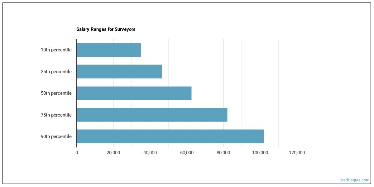
Surveyors who work in California, Washington, or Nevada, make the highest salaries.
How much do Surveyors make in each U.S. state?
| State | Annual Mean Salary |
|---|---|
| Alabama | $56,010 |
| Alaska | $79,940 |
| Arizona | $62,050 |
| Arkansas | $48,880 |
| California | $91,010 |
| Colorado | $66,010 |
| Connecticut | $70,810 |
| Delaware | $73,110 |
| Florida | $57,930 |
| Georgia | $59,500 |
| Hawaii | $65,880 |
| Idaho | $65,550 |
| Illinois | $72,540 |
| Indiana | $60,890 |
| Iowa | $65,250 |
| Kansas | $58,420 |
| Kentucky | $56,510 |
| Louisiana | $62,810 |
| Maine | $59,360 |
| Maryland | $65,220 |
| Massachusetts | $66,000 |
| Michigan | $58,850 |
| Minnesota | $65,950 |
| Mississippi | $46,660 |
| Missouri | $59,980 |
| Montana | $63,020 |
| Nebraska | $54,750 |
| Nevada | $80,520 |
| New Hampshire | $63,710 |
| New Jersey | $70,120 |
| New Mexico | $74,470 |
| New York | $77,660 |
| North Carolina | $70,460 |
| North Dakota | $75,360 |
| Ohio | $62,520 |
| Oklahoma | $54,130 |
| Oregon | $68,130 |
| Pennsylvania | $62,400 |
| Rhode Island | $60,070 |
| South Carolina | $49,570 |
| South Dakota | $67,970 |
| Tennessee | $49,280 |
| Texas | $59,980 |
| Utah | $69,150 |
| Vermont | $51,890 |
| Virginia | $70,230 |
| Washington | $85,860 |
| West Virginia | $65,750 |
| Wisconsin | $62,820 |
| Wyoming | $66,160 |
What Tools & Technology do Surveyors Use?
Below is a list of the types of tools and technologies that Surveyors may use on a daily basis:
- Microsoft Excel
- Microsoft Word
- Microsoft Office
- Autodesk AutoCAD
- Spreadsheet software
- Geographic information system GIS software
- Bentley MicroStation
- ESRI ArcView
- Autodesk AutoCAD Civil 3D
- Internet browser software
- Computer aided design and drafting software CADD
- Global positioning system GPS software
- Geomechanical design analysis GDA software
- ESRI ArcGIS software
- Data logging software
- Bentley Systems InRoads Suite
- Bentley GeoPak Bridge
- Carlson SurvCADD
- Trimble Terramodel
- Survey software
Becoming a Surveyor
Individuals working as a Surveyor have obtained the following education levels:

How many years of work experience do I need?

Where Surveyors Work

Surveyors work in the following industries:

You May Also Be Interested In…
Those thinking about becoming a Surveyor might also be interested in the following careers:
References:
Image Credit: Mike1979 Russia via Creative Commons Attribution-Share Alike 3.0 Unported
More about our data sources and methodologies.
Featured Schools
GradDegree.com provides higher-education, college and university, degree, program, career, salary, and other helpful information to students, faculty, institutions, and other internet audiences. Presented information and data are subject to change. Inclusion on this website does not imply or represent a direct relationship with the company, school, or brand. Information, though believed correct at time of publication, may not be correct, and no warranty is provided. Contact the schools to verify any information before relying on it. Financial aid may be available for those who qualify. The displayed options may include sponsored or recommended results, not necessarily based on your preferences.
© GradDegree.com – All Rights Reserved.