What Do Remote Sensing Technician Do?
Occupation Description Apply remote sensing technologies to assist scientists in areas such as natural resources, urban planning, or homeland security. May prepare flight plans or sensor configurations for flight trips.
List of Remote Sensing Technician Job Duties
- Evaluate remote sensing project requirements to determine the types of equipment or computer software necessary to meet project requirements, such as specific image types or output resolutions.
- Adjust remotely sensed images for optimum presentation by using software to select image displays, define image set categories, or choose processing routines.
- Develop or maintain geospatial information databases.
- Prepare documentation or presentations, including charts, photos, or graphs.
- Develop specialized computer software routines to customize and integrate image analysis.
- Monitor raw data quality during collection and make equipment corrections as necessary.
Featured schools near , edit
Things a Remote Sensing Technician Should Know How to Do
These are the skills Remote Sensing Technicians say are the most useful in their careers:
Critical Thinking: Using logic and reasoning to identify the strengths and weaknesses of alternative solutions, conclusions or approaches to problems.
Speaking: Talking to others to convey information effectively.
Mathematics: Using mathematics to solve problems.
Reading Comprehension: Understanding written sentences and paragraphs in work related documents.
Active Listening: Giving full attention to what other people are saying, taking time to understand the points being made, asking questions as appropriate, and not interrupting at inappropriate times.
Systems Analysis: Determining how a system should work and how changes in conditions, operations, and the environment will affect outcomes.
Types of Remote Sensing Technician
- Graphics Edit Technician
- Mosaic Technician
- Senior Research Analyst
- Digital Cartographic Technician
- IP/Mosaic Technician
Job Outlook for Remote Sensing Technicians
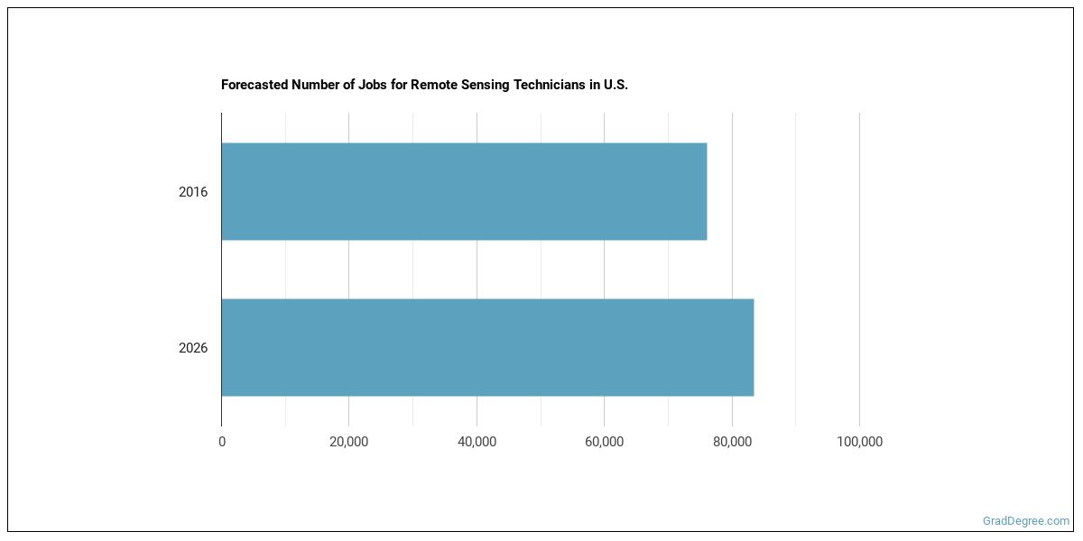
There were about 76,100 jobs for Remote Sensing Technician in 2016 (in the United States). New jobs are being produced at a rate of 9.7% which is above the national average. The Bureau of Labor Statistics predicts 7,400 new jobs for Remote Sensing Technician by 2026. There will be an estimated 9,900 positions for Remote Sensing Technician per year.
The states with the most job growth for Remote Sensing Technician are Utah, Texas, and Nevada. Watch out if you plan on working in Wyoming, Maine, or Alaska. These states have the worst job growth for this type of profession.
Remote Sensing Technician Salary
The salary for Remote Sensing Technicians ranges between about $29,830 and $80,370 a year.

Remote Sensing Technicians who work in Maryland, Connecticut, or Rhode Island, make the highest salaries.
How much do Remote Sensing Technicians make in each U.S. state?
| State | Annual Mean Salary |
|---|---|
| Alabama | $46,600 |
| Alaska | $56,470 |
| Arizona | $51,250 |
| Arkansas | $50,740 |
| California | $56,670 |
| Colorado | $51,890 |
| Connecticut | $62,090 |
| District of Columbia | $61,000 |
| Florida | $45,200 |
| Georgia | $52,690 |
| Hawaii | $57,310 |
| Idaho | $42,220 |
| Illinois | $51,130 |
| Indiana | $51,970 |
| Iowa | $46,740 |
| Kansas | $51,960 |
| Kentucky | $52,340 |
| Louisiana | $47,250 |
| Maine | $55,220 |
| Maryland | $69,500 |
| Massachusetts | $63,450 |
| Michigan | $43,640 |
| Minnesota | $50,440 |
| Mississippi | $52,950 |
| Missouri | $49,590 |
| Montana | $43,930 |
| Nebraska | $58,150 |
| Nevada | $47,690 |
| New Hampshire | $57,990 |
| New Jersey | $60,660 |
| New Mexico | $59,850 |
| New York | $53,380 |
| North Carolina | $53,390 |
| North Dakota | $52,050 |
| Ohio | $52,690 |
| Oklahoma | $57,950 |
| Oregon | $51,800 |
| Pennsylvania | $50,410 |
| Rhode Island | $59,480 |
| South Carolina | $56,910 |
| South Dakota | $45,190 |
| Tennessee | $43,440 |
| Texas | $54,290 |
| Utah | $50,980 |
| Virginia | $52,180 |
| Washington | $55,920 |
| West Virginia | $55,930 |
| Wisconsin | $52,500 |
| Wyoming | $53,940 |
What Tools & Technology do Remote Sensing Technicians Use?
Below is a list of the types of tools and technologies that Remote Sensing Technicians may use on a daily basis:
- Microsoft Excel
- Microsoft Word
- Microsoft Office
- Microsoft PowerPoint
- Web browser software
- Python
- Microsoft Access
- Microsoft Project
- Autodesk AutoCAD
- The MathWorks MATLAB
- SAS
- UNIX
- R
- Bentley Microstation
- Global positioning system GPS software
- Leica Geosystems ERDAS IMAGINE
- ESRI ArcGIS software
- Interface definition language IDL
- ESRI ArcView 3D Analyst
- ITT Visual Information Solutions ENVI
How do I Become a Remote Sensing Technician?
Learn what Remote Sensing Technician education requirements there are.

How Long Does it Take to Become a Remote Sensing Technician?

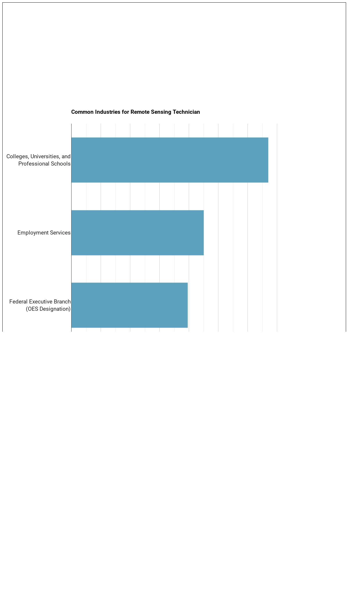
Where do Remote Sensing Technicians Work?

The table below shows the approximate number of Remote Sensing Technicians employed by various industries.
References:
Image Credit: U.S. Department of Energy from United States via public domain
More about our data sources and methodologies.
Featured Schools
GradDegree.com provides higher-education, college and university, degree, program, career, salary, and other helpful information to students, faculty, institutions, and other internet audiences. Presented information and data are subject to change. Inclusion on this website does not imply or represent a direct relationship with the company, school, or brand. Information, though believed correct at time of publication, may not be correct, and no warranty is provided. Contact the schools to verify any information before relying on it. Financial aid may be available for those who qualify. The displayed options may include sponsored or recommended results, not necessarily based on your preferences.
© GradDegree.com – All Rights Reserved.