Life As a Remote Sensing Scientist or Technologist
Remote Sensing Scientist or Technologist Job Description Apply remote sensing principles and methods to analyze data and solve problems in areas such as natural resource management, urban planning, or homeland security. May develop new sensor systems, analytical techniques, or new applications for existing systems.
Life As a Remote Sensing Scientist or Technologist: What Do They Do?
- Apply remote sensing data or techniques, such as surface water modeling or dust cloud detection, to address environmental issues.
- Develop or build databases for remote sensing or related geospatial project information.
- Participate in fieldwork.
- Conduct research into the application or enhancement of remote sensing technology.
- Organize and maintain geospatial data and associated documentation.
- Monitor quality of remote sensing data collection operations to determine if procedural or equipment changes are necessary.
Featured schools near , edit
Remote Sensing Scientist or Technologist Skills
These are the skills Remote Sensing Scientists and Technologists say are the most useful in their careers:
Reading Comprehension: Understanding written sentences and paragraphs in work related documents.
Science: Using scientific rules and methods to solve problems.
Critical Thinking: Using logic and reasoning to identify the strengths and weaknesses of alternative solutions, conclusions or approaches to problems.
Complex Problem Solving: Identifying complex problems and reviewing related information to develop and evaluate options and implement solutions.
Writing: Communicating effectively in writing as appropriate for the needs of the audience.
Speaking: Talking to others to convey information effectively.
Related Job Titles for this Occupation:
- Weather Algorithm Scientist
- Scientist
- Remote Sensing Technologist
- Remote Sensing Certified Mapping Scientist
- Data Analytics Chief Scientist
Job Demand for Remote Sensing Scientists and Technologists
In 2016, there was an estimated number of 23,500 jobs in the United States for Remote Sensing Scientist or Technologist. New jobs are being produced at a rate of 6.8% which is above the national average. The Bureau of Labor Statistics predicts 1,600 new jobs for Remote Sensing Scientist or Technologist by 2026. Due to new job openings and attrition, there will be an average of 2,000 job openings in this field each year.

The states with the most job growth for Remote Sensing Scientist or Technologist are Nevada, Nebraska, and New Mexico. Watch out if you plan on working in Wyoming, West Virginia, or Tennessee. These states have the worst job growth for this type of profession.
Salary for a Remote Sensing Scientist or Technologist
The salary for Remote Sensing Scientists and Technologists ranges between about $51,730 and $164,210 a year.
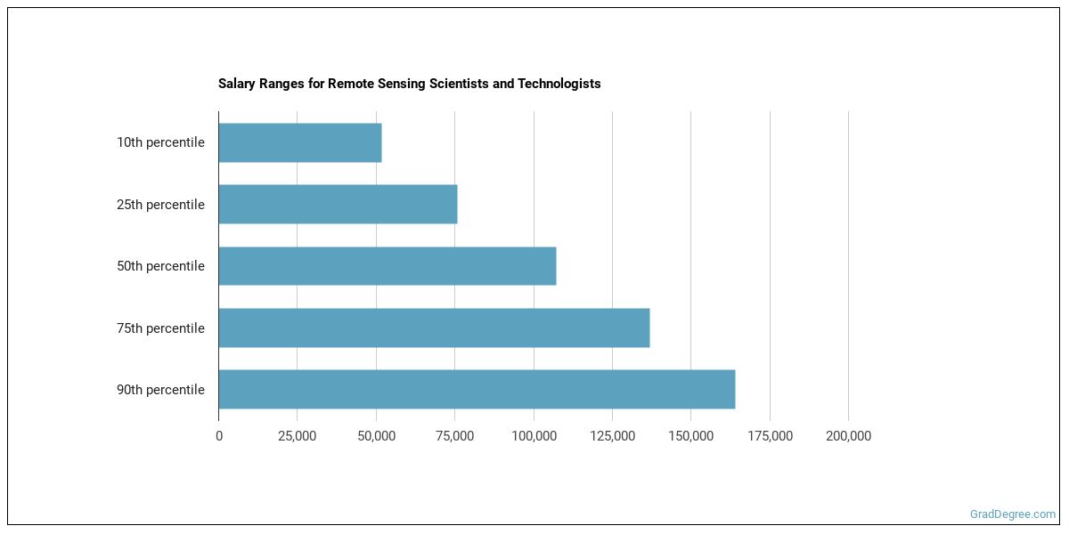
Remote Sensing Scientists and Technologists who work in District of Columbia, Maryland, or New Mexico, make the highest salaries.
How much do Remote Sensing Scientists and Technologists make in different U.S. states?
| State | Annual Mean Salary |
|---|---|
| Alabama | $122,420 |
| Alaska | $95,380 |
| Arizona | $87,870 |
| California | $117,830 |
| Colorado | $116,530 |
| Connecticut | $108,770 |
| District of Columbia | $134,100 |
| Florida | $88,270 |
| Georgia | $106,560 |
| Hawaii | $97,080 |
| Idaho | $64,900 |
| Illinois | $97,720 |
| Indiana | $81,740 |
| Kansas | $97,300 |
| Kentucky | $94,700 |
| Louisiana | $99,540 |
| Maryland | $130,450 |
| Massachusetts | $111,910 |
| Michigan | $94,810 |
| Mississippi | $87,010 |
| Missouri | $92,960 |
| Montana | $64,320 |
| New Hampshire | $89,600 |
| New Jersey | $96,850 |
| New Mexico | $127,210 |
| New York | $103,970 |
| North Carolina | $96,450 |
| North Dakota | $47,990 |
| Ohio | $102,370 |
| Oklahoma | $83,960 |
| Oregon | $82,560 |
| Pennsylvania | $115,050 |
| Rhode Island | $108,290 |
| South Carolina | $116,000 |
| Tennessee | $90,800 |
| Texas | $101,320 |
| Virginia | $121,850 |
| Washington | $108,430 |
| West Virginia | $103,810 |
| Wisconsin | $78,180 |
Tools & Technologies Used by Remote Sensing Scientists and Technologists
Below is a list of the types of tools and technologies that Remote Sensing Scientists and Technologists may use on a daily basis:
- Microsoft Excel
- Microsoft Word
- Microsoft Office
- Microsoft PowerPoint
- Web browser software
- Structured query language SQL
- The MathWorks MATLAB
- Linux
- UNIX
- C
- Practical extraction and reporting language Perl
- Leica Geosystems ERDAS IMAGINE
- ESRI ArcGIS software
- Interface definition language IDL
- Image processing software
- C++
- RSI ENVI
Becoming a Remote Sensing Scientist or Technologist
Education needed to be a Remote Sensing Scientist or Technologist:

How many years of work experience do I need?

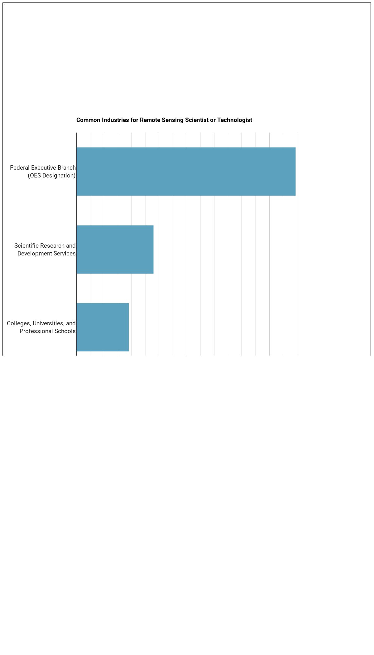
Where Remote Sensing Scientists and Technologists Work

The table below shows some of the most common industries where those employed in this career field work.
Related Careers
Those thinking about becoming a Remote Sensing Scientist or Technologist might also be interested in the following careers:
References:
Image Credit: Agsftw via Creative Commons Attribution-Share Alike 3.0 Unported
More about our data sources and methodologies.
Featured Schools
GradDegree.com provides higher-education, college and university, degree, program, career, salary, and other helpful information to students, faculty, institutions, and other internet audiences. Presented information and data are subject to change. Inclusion on this website does not imply or represent a direct relationship with the company, school, or brand. Information, though believed correct at time of publication, may not be correct, and no warranty is provided. Contact the schools to verify any information before relying on it. Financial aid may be available for those who qualify. The displayed options may include sponsored or recommended results, not necessarily based on your preferences.
© GradDegree.com – All Rights Reserved.