All About Geodetic Surveyors
Career Description Measure large areas of the Earth’s surface using satellite observations, global navigation satellite systems (GNSS), light detection and ranging (LIDAR), or related sources.
Life As a Geodetic Surveyor: What Do They Do?
- Verify the mathematical correctness of newly collected survey data.
- Distribute compiled geodetic data to government agencies or the general public.
- Determine orientation of tracts of land, including position, boundaries, size, and shape, using theodolites, electronic distance-measuring equipment, satellite-based positioning equipment, land information systems, or other geodetic survey equipment.
- Compute horizontal and vertical coordinates of control networks, using direct leveling or other geodetic survey techniques, such as triangulation, trilateration, and traversing, to establish features of the Earth’s surface.
- Plan or direct the work of geodetic surveying staff, providing technical consultation as needed.
- Request additional survey data when field collection errors occur or engineering surveying specifications are not maintained.
Featured schools near , edit
Geodetic Surveyor Skills
Geodetic Surveyors state the following job skills are important in their day-to-day work.
Mathematics: Using mathematics to solve problems.
Critical Thinking: Using logic and reasoning to identify the strengths and weaknesses of alternative solutions, conclusions or approaches to problems.
Reading Comprehension: Understanding written sentences and paragraphs in work related documents.
Active Listening: Giving full attention to what other people are saying, taking time to understand the points being made, asking questions as appropriate, and not interrupting at inappropriate times.
Complex Problem Solving: Identifying complex problems and reviewing related information to develop and evaluate options and implement solutions.
Judgment and Decision Making: Considering the relative costs and benefits of potential actions to choose the most appropriate one.
Types of Geodetic Surveyor Jobs
- Digital Measurement Advisor
- Licensed Land Surveyor
- Geodetic Advisor
- Remote Sensing Advisor
- Geodetic Surveyor
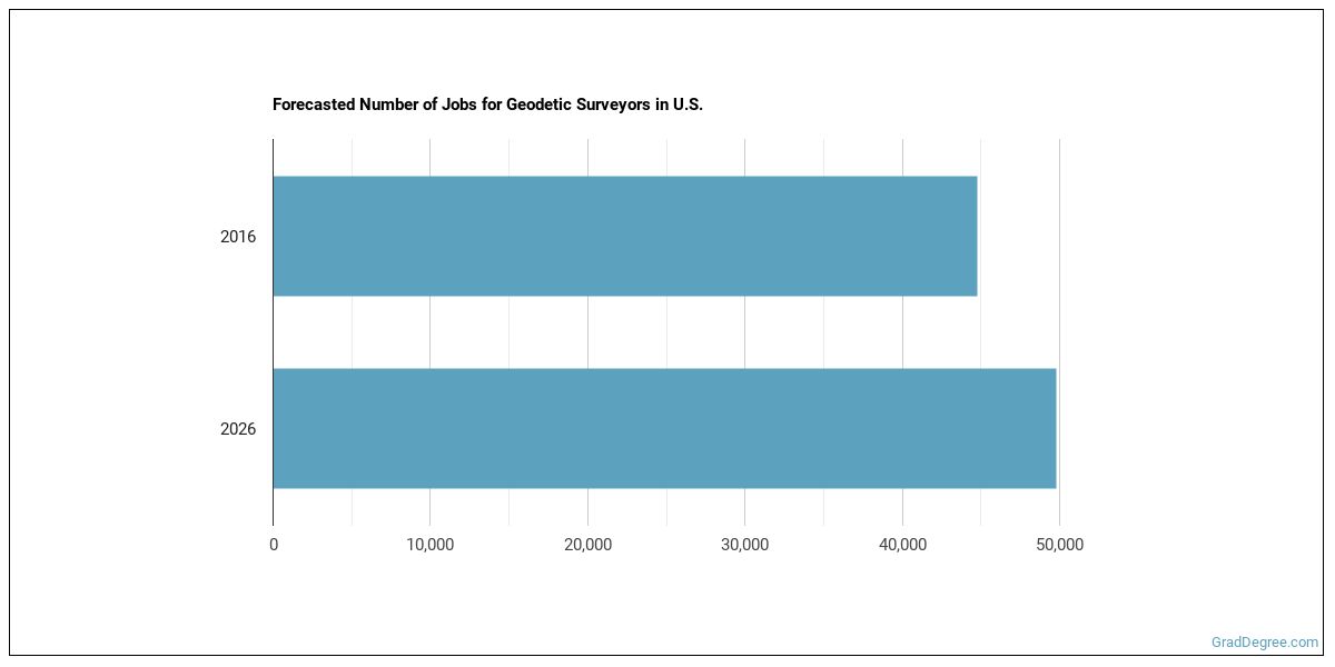
Geodetic Surveyor Employment Estimates
In the United States, there were 44,800 jobs for Geodetic Surveyor in 2016. New jobs are being produced at a rate of 11.2% which is above the national average. The Bureau of Labor Statistics predicts 5,000 new jobs for Geodetic Surveyor by 2026. Due to new job openings and attrition, there will be an average of 3,800 job openings in this field each year.
The states with the most job growth for Geodetic Surveyor are Utah, Florida, and North Dakota. Watch out if you plan on working in Vermont, Washington, or Maine. These states have the worst job growth for this type of profession.
Salary for a Geodetic Surveyor
The typical yearly salary for Geodetic Surveyors is somewhere between $35,160 and $102,220.

Geodetic Surveyors who work in California, Washington, or Nevada, make the highest salaries.
Below is a list of the median annual salaries for Geodetic Surveyors in different U.S. states.
| State | Annual Mean Salary |
|---|---|
| Alabama | $56,010 |
| Alaska | $79,940 |
| Arizona | $62,050 |
| Arkansas | $48,880 |
| California | $91,010 |
| Colorado | $66,010 |
| Connecticut | $70,810 |
| Delaware | $73,110 |
| Florida | $57,930 |
| Georgia | $59,500 |
| Hawaii | $65,880 |
| Idaho | $65,550 |
| Illinois | $72,540 |
| Indiana | $60,890 |
| Iowa | $65,250 |
| Kansas | $58,420 |
| Kentucky | $56,510 |
| Louisiana | $62,810 |
| Maine | $59,360 |
| Maryland | $65,220 |
| Massachusetts | $66,000 |
| Michigan | $58,850 |
| Minnesota | $65,950 |
| Mississippi | $46,660 |
| Missouri | $59,980 |
| Montana | $63,020 |
| Nebraska | $54,750 |
| Nevada | $80,520 |
| New Hampshire | $63,710 |
| New Jersey | $70,120 |
| New Mexico | $74,470 |
| New York | $77,660 |
| North Carolina | $70,460 |
| North Dakota | $75,360 |
| Ohio | $62,520 |
| Oklahoma | $54,130 |
| Oregon | $68,130 |
| Pennsylvania | $62,400 |
| Rhode Island | $60,070 |
| South Carolina | $49,570 |
| South Dakota | $67,970 |
| Tennessee | $49,280 |
| Texas | $59,980 |
| Utah | $69,150 |
| Vermont | $51,890 |
| Virginia | $70,230 |
| Washington | $85,860 |
| West Virginia | $65,750 |
| Wisconsin | $62,820 |
| Wyoming | $66,160 |
Tools & Technologies Used by Geodetic Surveyors
Below is a list of the types of tools and technologies that Geodetic Surveyors may use on a daily basis:
- Microsoft Excel
- Microsoft Word
- Microsoft Office
- Hypertext markup language HTML
- Web browser software
- Email software
- Autodesk AutoCAD
- Geographic information system GIS software
- Bentley Microstation
- ESRI ArcView
- ESRI ArcGIS software
- Virtual reality modeling language VRML software
- Trimble Terramodel
- Traverse PC
- Autodesk CAiCE Visual Transportation
- SiteComp Survey
- QuickCogo
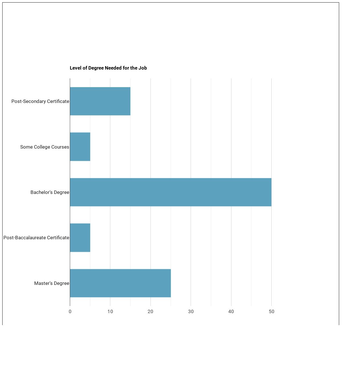
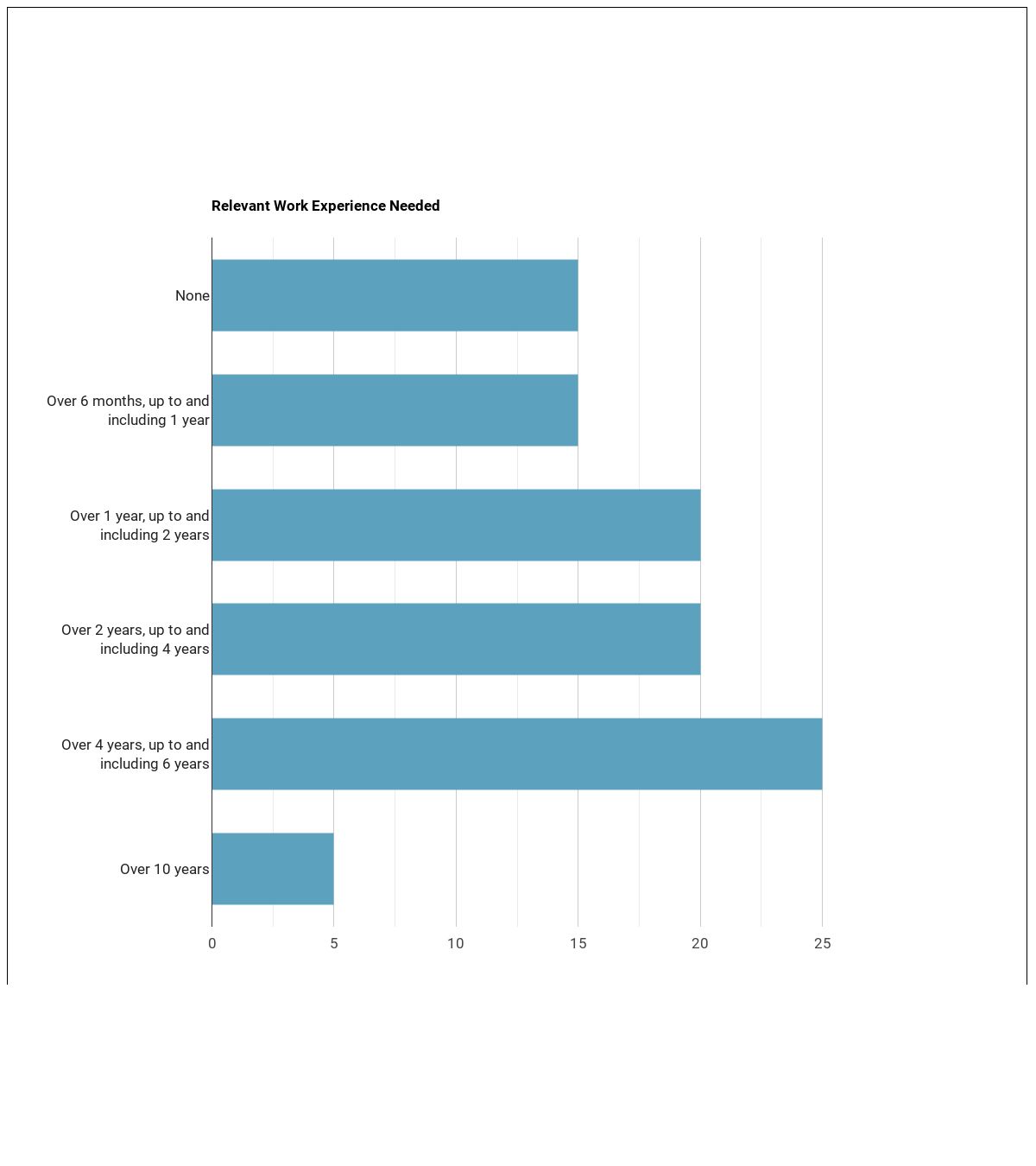
Becoming a Geodetic Surveyor
What kind of Geodetic Surveyor requirements are there?
How many years of work experience do I need?
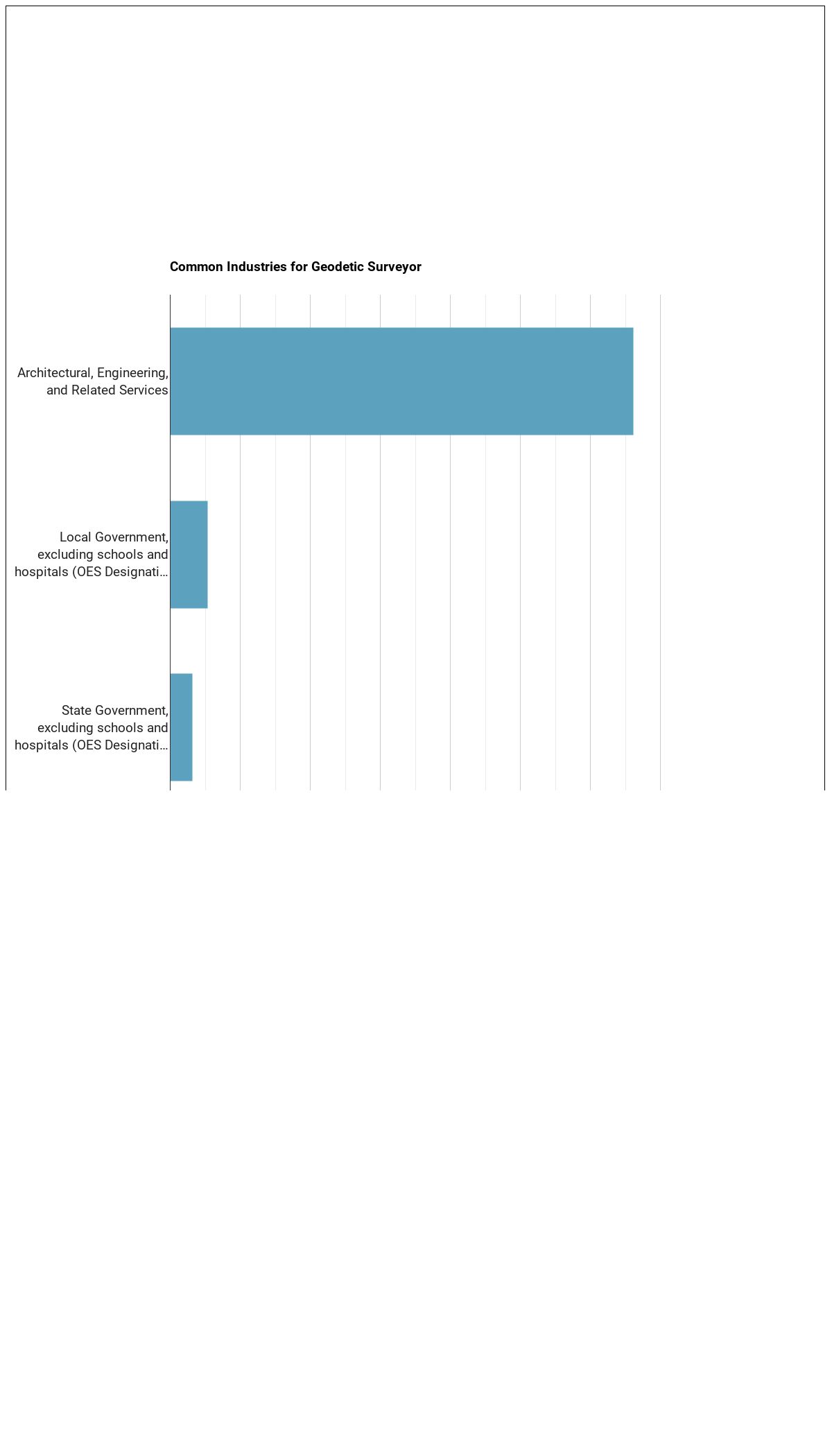
Who Employs Geodetic Surveyors?

The table below shows some of the most common industries where those employed in this career field work.
Similar Careers
Those interested in being a Geodetic Surveyor may also be interested in:
Are you already one of the many Geodetic Surveyor in the United States? If you’re thinking about changing careers, these fields are worth exploring:
References:
Image Credit: Mike1979 Russia via Creative Commons Attribution-Share Alike 3.0 Unported
More about our data sources and methodologies.
Featured Schools
GradDegree.com provides higher-education, college and university, degree, program, career, salary, and other helpful information to students, faculty, institutions, and other internet audiences. Presented information and data are subject to change. Inclusion on this website does not imply or represent a direct relationship with the company, school, or brand. Information, though believed correct at time of publication, may not be correct, and no warranty is provided. Contact the schools to verify any information before relying on it. Financial aid may be available for those who qualify. The displayed options may include sponsored or recommended results, not necessarily based on your preferences.
© GradDegree.com – All Rights Reserved.