Life As a Cartographer or Photogrammetrist
Example of Cartographer or Photogrammetrist Job Collect, analyze, and interpret geographic information provided by geodetic surveys, aerial photographs, and satellite data. Research, study, and prepare maps and other spatial data in digital or graphic form for legal, social, political, educational, and design purposes. May work with Geographic Information Systems (GIS). May design and evaluate algorithms, data structures, and user interfaces for GIS and mapping systems.
Daily Life Of a Cartographer or Photogrammetrist
- Revise existing maps and charts, making all necessary corrections and adjustments.
- Determine guidelines that specify which source material is acceptable for use.
- Identify, scale, and orient geodetic points, elevations, and other planimetric or topographic features, applying standard mathematical formulas.
- Build and update digital databases.
- Study legal records to establish boundaries of local, national, and international properties.
- Determine map content and layout, as well as production specifications such as scale, size, projection, and colors, and direct production to ensure that specifications are followed.
Featured schools near , edit
Cartographer or Photogrammetrist Skills
These are the skills Cartographers and Photogrammetrists say are the most useful in their careers:
Reading Comprehension: Understanding written sentences and paragraphs in work related documents.
Writing: Communicating effectively in writing as appropriate for the needs of the audience.
Critical Thinking: Using logic and reasoning to identify the strengths and weaknesses of alternative solutions, conclusions or approaches to problems.
Active Listening: Giving full attention to what other people are saying, taking time to understand the points being made, asking questions as appropriate, and not interrupting at inappropriate times.
Active Learning: Understanding the implications of new information for both current and future problem-solving and decision-making.
Judgment and Decision Making: Considering the relative costs and benefits of potential actions to choose the most appropriate one.
Types of Cartographer or Photogrammetrist Jobs
- Digital Cartographer
- Cartography Supervisor
- Stereo Compiler
- Aerial Photogrammetrist
- Photogrammetric Engineer
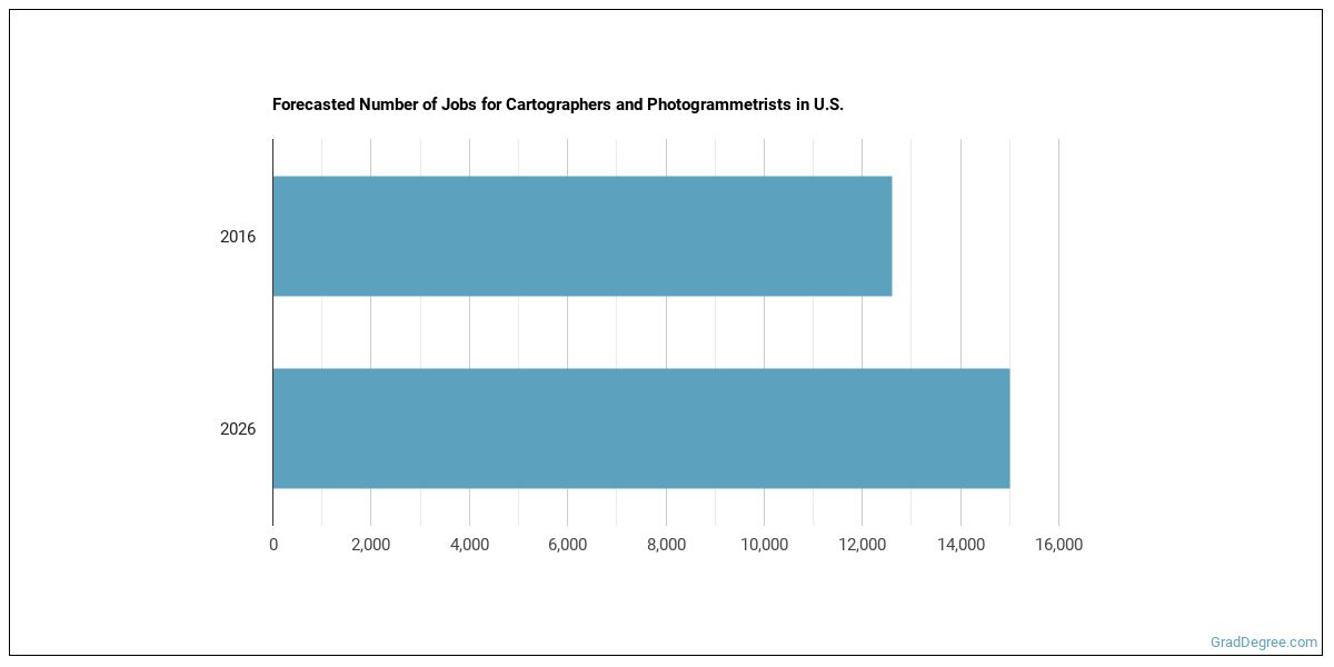
What Kind of Cartographer or Photogrammetrist Job Opportunities Are There?
In the United States, there were 12,600 jobs for Cartographer or Photogrammetrist in 2016. New jobs are being produced at a rate of 19% which is above the national average. The Bureau of Labor Statistics predicts 2,400 new jobs for Cartographer or Photogrammetrist by 2026. Due to new job openings and attrition, there will be an average of 1,200 job openings in this field each year.
The states with the most job growth for Cartographer or Photogrammetrist are Colorado, Oregon, and Utah. Watch out if you plan on working in Rhode Island, Mississippi, or Maine. These states have the worst job growth for this type of profession.
Do Cartographers and Photogrammetrists Make A Lot Of Money?
The salary for Cartographers and Photogrammetrists ranges between about $40,960 and $101,400 a year.

Cartographers and Photogrammetrists who work in New Jersey, California, or Washington, make the highest salaries.
How much do Cartographers and Photogrammetrists make in different U.S. states?
| State | Annual Mean Salary |
|---|---|
| Alabama | $65,660 |
| Alaska | $67,920 |
| Arizona | $66,830 |
| Arkansas | $52,480 |
| California | $84,540 |
| Colorado | $73,150 |
| Connecticut | $72,270 |
| Florida | $62,160 |
| Georgia | $54,620 |
| Hawaii | $67,670 |
| Idaho | $56,350 |
| Illinois | $77,070 |
| Indiana | $57,420 |
| Kansas | $58,710 |
| Kentucky | $70,060 |
| Louisiana | $71,480 |
| Maine | $67,460 |
| Maryland | $79,440 |
| Massachusetts | $73,290 |
| Michigan | $65,610 |
| Minnesota | $71,070 |
| Mississippi | $58,840 |
| Missouri | $64,270 |
| Montana | $52,130 |
| Nebraska | $68,150 |
| Nevada | $75,300 |
| New Hampshire | $53,990 |
| New Jersey | $84,120 |
| New Mexico | $69,250 |
| New York | $78,780 |
| North Carolina | $56,530 |
| Ohio | $70,550 |
| Oklahoma | $56,250 |
| Oregon | $64,290 |
| Pennsylvania | $63,360 |
| South Carolina | $53,020 |
| South Dakota | $55,310 |
| Tennessee | $58,380 |
| Texas | $64,620 |
| Utah | $57,310 |
| Vermont | $62,940 |
| Virginia | $81,750 |
| Washington | $81,620 |
| West Virginia | $55,030 |
| Wisconsin | $64,490 |
| Wyoming | $57,110 |
Tools & Technologies Used by Cartographers and Photogrammetrists
Below is a list of the types of tools and technologies that Cartographers and Photogrammetrists may use on a daily basis:
- Microsoft Excel
- Microsoft Word
- Microsoft Office
- Microsoft PowerPoint
- Microsoft Outlook
- Python
- Microsoft Access
- Email software
- Word processing software
- SAP
- Microsoft Windows
- Autodesk AutoCAD
- Adobe Systems Adobe Acrobat
- Spreadsheet software
- Microsoft SharePoint
- Adobe Systems Adobe Photoshop
- Structured query language SQL
- Microsoft Visual Basic
- Adobe Systems Adobe Illustrator
- Extensible markup language XML
How to Become a Cartographer or Photogrammetrist
Are there Cartographers and Photogrammetrists education requirements?

How many years of work experience do I need?

Who Employs Cartographers and Photogrammetrists?

Below are examples of industries where Cartographers and Photogrammetrists work:

References:
Image Credit: Couleur via public domain (CC0)
More about our data sources and methodologies.
Featured Schools
GradDegree.com provides higher-education, college and university, degree, program, career, salary, and other helpful information to students, faculty, institutions, and other internet audiences. Presented information and data are subject to change. Inclusion on this website does not imply or represent a direct relationship with the company, school, or brand. Information, though believed correct at time of publication, may not be correct, and no warranty is provided. Contact the schools to verify any information before relying on it. Financial aid may be available for those who qualify. The displayed options may include sponsored or recommended results, not necessarily based on your preferences.
© GradDegree.com – All Rights Reserved.